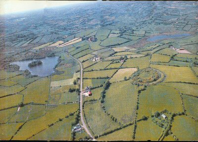
At the top of the picture are the townlands of Drumlougher and Kiltybane with Lough Patrick on the left. On the right middle is the famous three-ringed Royal Fort of Lisleitrim. There was once a souterrain on its top level but – though still existing – this has been filled in with soil.
The Souterrain
We cut the sod. We dug the heavy mould
To bare the stones which stronger folk have laid
Over their tunnelled dwelling. Pick and spade
Reminded shoulder, forearm, we grew old,
Save for the lad whose easy gestures told
That this was something near his daily trade.
Absolved by age, the nodding farmer made
A ready bet we’d crack no crock of gold.
When the large stone was scraped, was bared to light
And shifted as the soil began to spill
In sandglass trickle slowly out of sight,
As the dark passage beckoned, deep and still,
For a hushed spell no crock of gold could buy
We brinked the silent pit of mystery.
John Hewitt
…
The lake with the ‘crannog’ on the left is locally known as the ‘island lake’. The other is known as Campbell’s Lake, with James Campbell’s house beside it. There is much furze (whins to you and me) on view, somewhat indicative of the shale bedrock. It is also the plant after which the whole area, The Fews, was named.
The famous Dorsey Enclosure is no more than three miles away. It is likely that this – with Lisleitrim, and the Dane’s Cast, Black Pig’s Dyke at Meigh, Scarva etc – formed a part of the extended earthen enclosures and embankments that marked (and protected) Emania and the Kingdom of Ulidia more than two millennia ago [the whole dates from the first century B.C.].
So much history in such a small region!
And just look at the countryside.
I just love South Armagh!!