In the century following the opening of the
Parliamentary Commissioners were appointed to enquire into the organisation of municipal corporations of
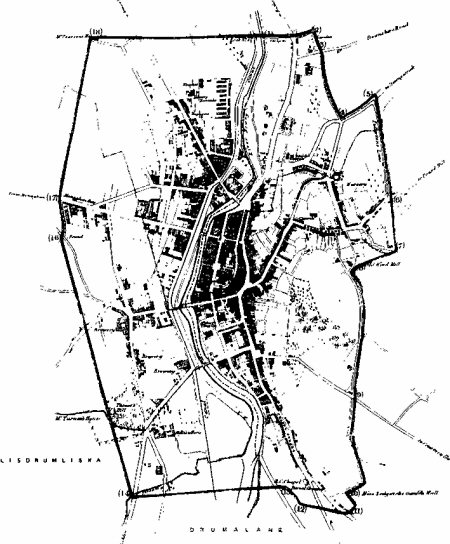
A close examination of the town’s boundaries as marked on this map yields the perhaps surprising revelation that the milestones so recently commented upon on our Discussion Board are located at the junctions of the town’s main roads with these boundaries! Perhaps this result is less surprising when we learn that the Local Government reform affected in the last decade of that century accepted these town boundaries and indeed, deemed that for administrative purposes, all of this area would fall within
For those curious enough to test my theory (that the ‘milestones’ demark the old municipal boundaries) it is relatively easy to check! I calculate, for example, that:
(3) is on Church Avenue; (4) and (5) on Rathfriland Road, the former close to its junction with Arthur Street and the latter, with Fullerton Road; (6) on Monk’s Hill; (7) Templehill Road (8) and (9) Windmill Road, the latter at its junction with Courtenay Hill. That’s most of the east side outlined for you! I’m sure you can complete the circuit.
If we are right and there are eighteen as marked on this map, we would like details of exact locations of the remaining milestones, perhaps with photographs!
It is obvious that this small-scale map with its inscriptions is difficult to read, so here are a few extra notes!
Number (18) – top left, is marked Mr Pearson’s House and your author estimates it was in the vicinity of the west entrance to today’s St Bridget’s Church, where Pighall Loanan from The Wheel at its junction with Camlough Road veered east to meet the Brickey Loanan and then Armagh Road (between (18) and (1) on this map). Looking the other direction on this map, between (18) and (17) the dotted line marks the vicinity of the Wheel! (16) is on the
And that’s more than enough! You don’t want me to do the whole thing, for you, do you?!!!