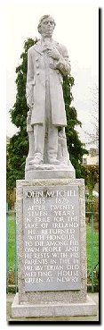
Just over there at the first rise of land in Dromalane, you can see the ivy-covered granite edifice that once was the home of Newry’s greatest patriot, John Mitchel who was exiled to Van Dieman’s Land for his outspoken political beliefs. From there he wrote …
“We are not far here, from the meridian of Newry, though six thousand miles to the south: and I know that this white disc struggling here through Antarctic storm clouds is the very globe of silver that hangs tonight between the branches of the laurels of Dromalane.”
As our small craft now forms a V-shaped wave on the Canal’s surface, we approach the spot where once this very Canal terminated at Fortesque’s Lock. Sea-going vessels were directed through a channel to port, into the fairway of the Clanrye river and Estuary.
[ Editors note: if you walk the Rampart today from behind the advertising hoardings opposite Orana House, you can see this same channel even today, now occasionally used to control water levels in the Canal.]
In the 1860’s the Ship Canal – terminating in the Victoria Locks – was constructed. That is our direction today. It is two miles distant. About halfway to that point the Ship Canal widens at a point that coincides with a sharp bend to the left in the tarmacadam roadway. This watery ‘turnaround’ was built to allow two sea-going vessels on the Ship Canal a place to pass each other in safety.
Stone is quarried from that Dromalane quarry to starboard for the construction of new roads, and buildings too.
And almost immediately now we note the mountains begin to ascend abruptly from the road and the young firs and spruce give the landscape a Norse quality.
Before the War all these slopes were wooded. Entirely denuded of timber to provide (amongst other things) pit props and trench supports, they are now replanted and look fresh and green this Spring morning”.
…. more Journey later ….