Shean townland lies around the southern and eastern foot of Slieve Brac which mountain lies to the west of Forkhill, and faces – across the valley – the beautiful, magical, mysterious, and legendary Slieve Gullion.
In fact all Catholic priests and other religious persons were being constantly harried, hunted and executed. Under this most harsh and tyrannical regime the Franciscan Friars were forced to have places of refuge and it just happens that one such refuge was founded in the townland of Shean.
That general area was not, in those days, as it is today. I have been told that the great wood of Dunreavy extended in those times from “Baile na Cleire” [the old placename for the present-day Ballsmill] all the way to Fathom.
There can be no doubt that the far-famed Big Seamus Murphy lived his short life (brought to an abrupt and cruel end) in Dunreavy Wood. His home was in Carnally (near Fords Cross). His eventful life will be a tale for another day. There is no remaining sign of the great wood in that area today. So it was and is with Forkhill and Shean.
The site of the Franciscan Friary at Shean was pointed out to me more than half a century ago by a man (even then, very old) whom I do not wish to name here for the reason that many local people regarded him as “not the full shilling” simply because he liked to talk about esoteric subjects such as the Franciscan Friars at Shean.
Fortunately I logged for future reference all he told me on the hard disc between my ears! It was to be many years before I read an article in C.L.A.H.J. (Co. LOUTH ARCHAEOLOGICAL AND HISTORICAL JOURNAL) that substantiated that which the man had told me.
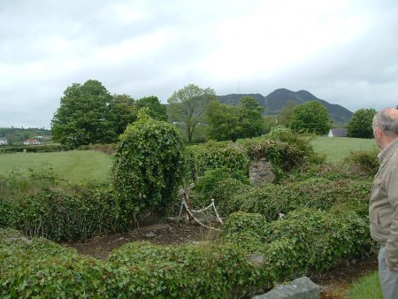
On the road eastward from Dungooley Cross one passes, on the left hand side, the mouth of Donnelly’s Road which leads to Carrive, and the southern end of the Bog Road which loops around Forkhill village to come out once more at Jacksons’ Plantin. Directly in front is the rather steep gradient of
It is this short stretch of road in which we are interested. Almost exactly half-way along that level stretch, on the left hand side lies the land of the late Barney O’Hanlon of Dungooley. Go through the gate to the roadside field and the site of the Franciscan foundation is there on your left hand side.
I have just noticed that the present gate has been slightly altered so that it now stands at an angle to the roadway. So it is straight through that gateway and the hallowed site is directly in front of you, a few yards into the field.
If you fail to find it, remember the adage… keep going in a straight line, because luckily the world is a sphere, and you will eventually get back to where you started.
Now, off you go…….
Editor’s addendum:
It is doubtful whether there is a townland in
At different times spelled Seean and Syan, the name is thought to have its origins in the Gaelic, meaning Fairy Mound. And how appropriate.
Forkhill is located in Shean, which is bounded by Dungooley (Louth, pictured above) and Longfield, Carrive, Shanroe and Carrickasticken in
Shean comprises almost one thousand acres in the Barony of
In 1571 the first Queen Elizabeth confiscated O’Hanlon land and granted Orior to Captain Thomas Chatterton. He however failed to found a settlement as she required. His grant was revoked. In the last decade of the sixteenth century Sir Oghy O’Hanlon, then chief of the Orior O’ Hanlons and married to a sister of Hugh O’Neill, Earl of Tyrone who led the Irish in the Nine Years War, failed to secure the family heritage.
It was still a long time before English settlers stayed in the area. By 1659 there were no colonists in Shean. Eventually however they came and stayed.