As we move forward in time in our archaeological review, we find the plentiful ring forts – especially plentiful in our area of interest – which were a feature of the early Christian era (c. 5th century-12th century).
These are earthen banks and ditches (raths) usually on the heavier soils, and with stone walls (cashels) on the rocky slopes of the ring dyke.
Good examples of cashels in our area were at Lisbanemore and Lisdoo (in the
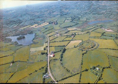
Raths are noticeably concentrated on the south and south-west slopes of the Ring of Gullion, particularly near Forkhill in Carrickasticken andd Tievecrom. At Lisleitrim near Cullyhanna (photographed above) is a spectacular hilltop rath with three substantial ditches and banks.
Crannogs (also above, to left) – island settlements – are also a feature of early Christian settlement. A crannog in the north of Cam Loch was drowned when levels of the
Throughout history routeways passing through the Ring of Gullion have had an important influence upon settlement. The Slige Midluacha, the ancient road from Newgrange (Drogheda) to Dunseverisk in North Antrim passed through the
…. more later …