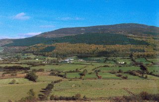
The Ring of Gullion, measuring roughly twenty-six miles by eleven and comprising some 15,000 hectares is defined topographically by the hills of the ring dyke.
The formation is practically unique globally and is thought to date originally to at least fifty million years ago at a time of great plate tectonic movement, when a collision of two massive plates may have dislodged into the earth’s mantle an enormous pluton that had intruded into the bottom of the crust at this point.
The subsequent recoil caused magma to pour out to Earth’s surface via fault lines- where it froze in situ to form Camlough and the other mountains surrounding the centrepiece, Gullion. Prior to this collision there had been an enormous volcano at this site – one of the highest ever seen on earth. This of course, was never (literally) seen as man did not evolve until approximately three million years ago (or rather the homo species that eventually evolved to homo sapiens sapiens – us!). Your editor likes to speculate (though one has never read it in the geologies!) that the line of hills to the east of Newry and stretching to Narrow Water comprise an outer ring of the Ring of Gullion, for it is surely possible that such a second dyke could have formed then, is of similar granitic rock type and it follows a roughly parallel course with the Camlough/Bernish/Fathom line.
The area of the Ring of Gullion Area of Outstanding Natural Beauty includes the Mountain Ring and its various slopes, but also there is a deviation to the West to include the famous Dorsey Enclosure. In the west it also includes the valley of the Cully Water and the