One of the interesting general histories of Newry past is that of Thomas Bradshaw, contained in Bradshaw’s General Directory of Newry (and other towns) of 1820. We quote sparingly from it ….
‘Formerly the principal part of the town stood immediately along the side of a steep hill which stretches nearly north and south: but since its commerce became more considerable, in consequence of improvements made in its navigation, the streets have extended in the direction of the river and the canal. Since the river and tide have been confined by embankments, many good houses have been built on ground formerly flooded by the tide.
Charles Havern, a man of one hundred and eleven years of age, remembered when the Low Ground was altogether a marsh; and afterwards when there were two bleach-greens where the coffee-room now stands.
As late as the year
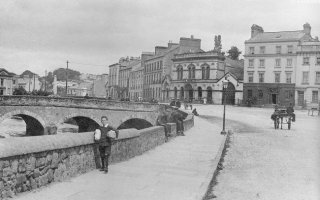
It is a good bridge of five arches. Formerly there were ten arches; but five of them being of no use for venting of water, it was thought unnecessary to retain them.’
A few lines of comment would not be out of place.
The steep hill is the
Bleach-greens were for the bleaching white of linen cloth, manufactured in the town’s vicinity.
The comment about the
And to my mind harks back to the Bagenal days when he was attempting to milk the maximum subvention from the English Exchequer for the building works he undertook about the town. A river that required TEN arches was clearly a more formidable obstacle than a mere five arch bridge!
Stand at the cannon today and gaze across. Why, you must wonder, were those far arches built into the bank of the river rather than helping to span or ford it?
I propose one theory.
Does any one have a better theory?